8.26.18 Describe the cross section of the typical cold front including cloud, temperature and freezing level changes, precipitation, and typical width.

Describe the cross section of the typical cold front including cloud, temperature and freezing level changes, precipitation, and typical width. 

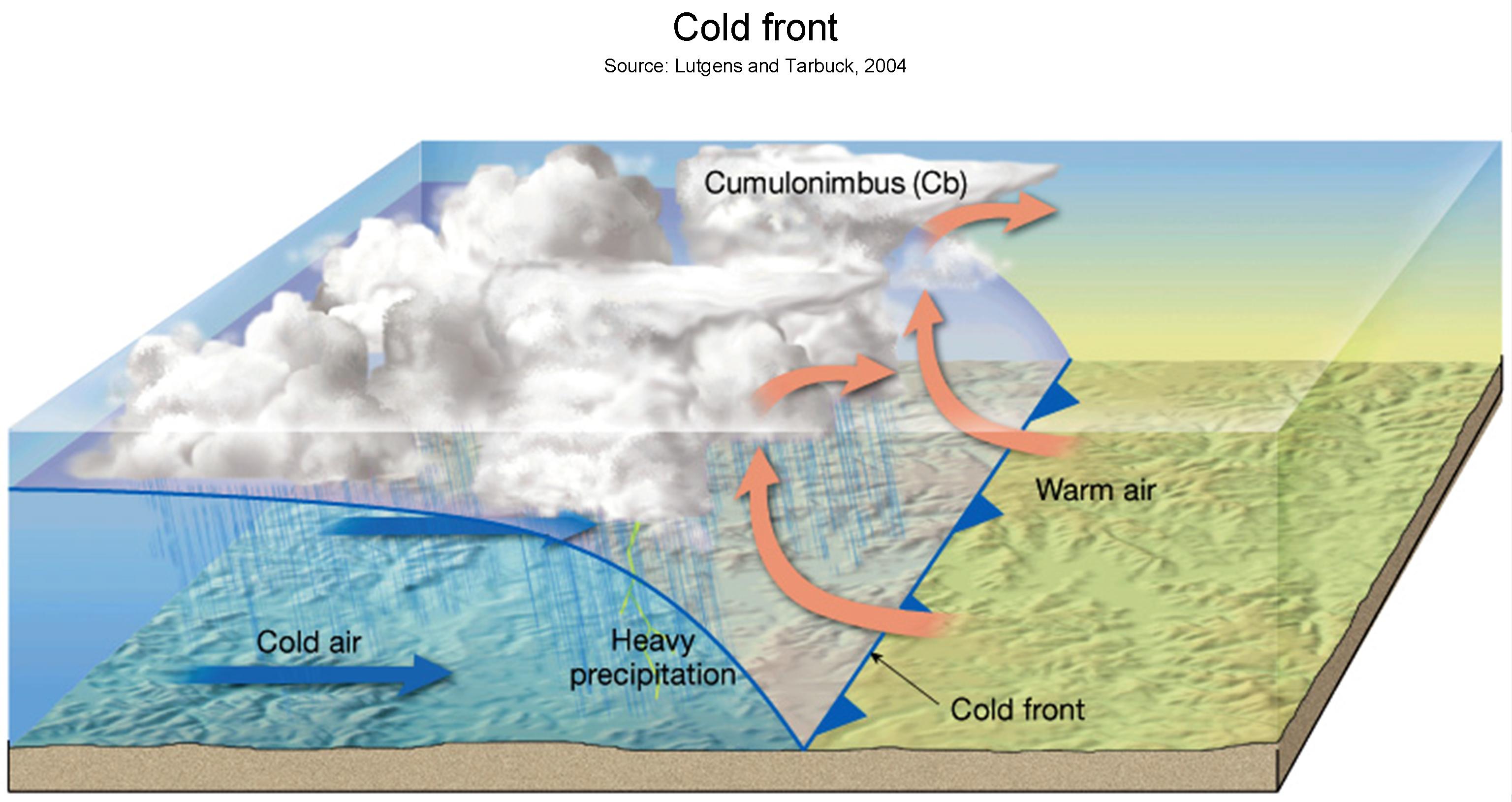
Cross Section of Cold Front;

Cold air overtakes warm air which is less dense and the cold air will undercut and lift the warm air

Cloud – typically cumuliform

Temperature – steady before, then an abrupt drop during, then cold steady afterward

Freezing level –

Precipitation – Nil before then showers including hail as the front passes through, then easing of showers and isolated showers afterwards

Width – typically 150km on average

8.26.16 Describes symbols and colours used for the following fronts on weather charts

State the symbols, and colour codes, used to describe the following fronts on weather charts: 
a)  cold front; 
b)  warm front; 
c)  occluded front; 
d)  stationary front. 

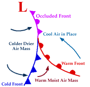
a) Cold Front
Lines with triangles on the advancing side
Lines are Blue

b) Warm Front

A Red line with half rounds on the advancing side

c) Occluded Front

Lines with triangles and half rounds on the same side
Purple lines

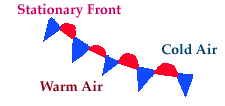
d) Stationary Front 
Here advancing warm air is equally and directly opposed by advancing warm air
Can be a dashed line without symbols on a weather chart or blue / red lines
Triangles point into the warm part and half rounds point into the cold sector.

8.26.14 Describe the following depression types

Describe the characteristics of the:
a)  mid-latitude depression; 
b)  orographic depression; 
c)  thermal (heat type) depression. 

a) Mid-latitude Depression

A depression forming in the mid-latitudes bringing in warm air from the tropics and sub-tropics

b) Orographic Depression
When a wind blows onto a mountain range some of the air is forced around the barrier and some goes partly over the top
This results in a “suction effect” on the lee side
This results in the formation of low pressures

c) Thermal (Heat type) depression
This is caused by the rising of air due to strong surface heating producing low level convergence for a localised depression to develop

8.26.12 Describe how divergence aloft affects the atmospheric pressure near sea level.

Describe how divergence aloft affects the atmospheric pressure near sea level.

??????? DISCUSSION

With high level divergence (movement away) we get low level convergence. 

8.36.4 Explain the typical weather conditions in New Zealand when affected by cold and warm advection.

Explain the typical weather conditions in New Zealand when affected by cold and warm advection. 

Cold advection:
– usually means sub-polar air moving North or North East which results in a South or South West wind
– when these winds encounter the mountain ranges of the North and South Islands; orographic lifting enhances the instability factor so major cumulus and cumulonimbus clouds develop

Warm advection:
– tropical air moves South or Southeast; causing a Northerly or North-Westerly wind
– cooling of the lower layers increases the relative humidity and stability of the air leading to stratiform cloud with low bases and rain or drizzle and poor visibility

Flip cards

'Flip Card' coming back Soon!

8.36.2 Describe what is meant by the following.

Describe what is meant by:
a)  cold advection; 
b)  warm advection. 

a) Cold Advection
This is cold air travelling towards warmer latitudes

b) Warm advection
This involves warm air travelling to colder latitudes and

8.36.16 Describe the typical associated factors for a Northerly flow onto NZ

8.36.16  Describe the typical associated factors for a Northerly flow onto NZ

(a) Stability; 

A northerly flow from the tropics or sub-tropics will be warm and very moist. As it moves south over a progressively
colder sea surface temperature, the airmass is cooled from below. This causes a low-level inversion to develop which
is a major indicator of stable atmospheric conditions. 

(b) Cloud types;
Even though the environment is stable, cloud can still form if there is a trigger to cause forced lifting. In a flow
originating in the sub-tropics, the lifting mechanism will be either frontal lifting caused by a warm front, or the
converging circulation surrounding a low of sub-tropical origin (both collectively fall under the heading of
‘widespread ascent’). In addition, further lifting may be caused over the New Zealand landmass by orographic lifting.
The clouds generated in this stable flow will be stratiform in nature i.e. clouds that form in layers: Stratus (St),
Stratocumulus (Sc), Altostratus (As), Nimbostratus (Ns), and Cirrostratus (Cs). 


(c) Likely precipitation; Any precipitation that does form within a stable flow must fall from stratiform cloud. Thus, the precipitation will be in
the form of continuous or intermittent rain or drizzle. 


(d) Visibility reductions; With an inversion close to the surface, the visibility will slowly decline prior to the arrival of any precipitation due to
pollutants getting trapped at low-levels. Prior to the rain, the visibility may drop over time to between 15 and 20 km.
Once the rain sets in, the visibility will drop to between 2000 m and 5000 m, and this condition may last for many
hours. 

(e) Turbulence; The severity of turbulence generated depends on the isobar spacing delivering this flow onto New Zealand. Often
the isobars are reasonably widely spaced, and so the turbulence generated is nothing more than light to moderate in
intensity. However, every now and then, a low of tropical or sub-tropical origin reinvigorates as it moves into New
Zealand latitudes, and the isobars can become very close. This of course, will generate severe turbulence when
orographically lifted.
In addition, there is likely to be a narrow zone of wind shear at the inversion, which will also generate light to
moderate turbulence.

So, to summarise:

In a northerly flow onto New Zealand… 

➡ The warm air is moving over a progressively colder sea surface…

     ➡ Therefore, it cools down near the surface… 

        ➡ This develops an inversion and increased stability…

            ➡ Any lifting results in stratiform clouds forming… 

                ➡ St, Sc, Ns, As and Cs, with very low bases possible… 

                    ➡ This results in continuous RA or DZ and … 

                        ➡ Poor visibility… 

                            ➡ With mostly light to moderate turbulence,
but severe if the isobars are close together.

8.36.14 Describe the typical associated factors for a Southerly flow onto NZ

8.36.14 Describe the typical associated factors for a Southerly flow onto NZ

(a) Stability; 

A southerly flow onto New Zealand will deliver cold, moist maritime polar (mP) air onto the country. As this cold air
flows northward, it moves over a progressively warmer sea or land surface. Thus, the air at low-levels is warmed from
below. This destabilises the airmass. 

(b) Cloud types; 

Convection begins to occur within this unstable airmass, and Cumulus (Cu), Towering Cumulus (TCu), and
Cumulonimbus (Cb) clouds form in the flow. These clouds, by their very nature, form in individual, separated, but
closely spaced convection currents. 

(c) Likely Precipitation; 

Cumuliform clouds like this produce ‘showers’ of rain, hail, snow or sleet. These showers may be very heavy and
frequent, but they fall in short bursts with short gaps between them when the weather is often quite good. 

(d) Visibility reductions; 

In showers, particularly heavy showers associated with Cb clouds, the visibility may be very poor – perhaps as low as
1000 m at times. In between showers however, the visibility will generally be very good. 

(e) Turbulence. 

Southerly flows are often quite strong, and on occasion, they reach storm force. Over land, moderate to severe
mechanical turbulence may exist, particularly in the lee of any ranges. Within the flow itself, turbulence within
cumulonimbus cells may be severe at times as is always the case with any Cb cloud.
The modification of a Southerly flow onto New Zealand is best summarised as follows:

A southerly flow onto New Zealand… 

➡ The cold air is moving over a progressively warmer sea surface… 

    ➡ Therefore, it warms up near the surface… 

        ➡ This results in increased instability… 

            ➡ Pockets of air break away from the surface (convection)… 

                ➡ Cu, TCu and Cb cloud form… 

                    ➡ Resulting in showers of rain, hail, snow & sleet 

                        ➡ Poor visibility at times…and 

                            ➡ It is often turbulent.
8.36.12 State the similarities between cold and warm fronts with reference to changes in the following;

8.36.12 State the similarities between cold and warm fronts with reference to changes in the following;

Temperature      Cold Front                                                           Warm Front

                           Steady – then falling post front                              Rising then steady post front

Pressure           Falling then rising                                                  Falling then steady

Wind                 NW backing to W or SW                                        E or NE backing to NW

  • Cloud            St and Cb in a narrow band                                  Inc layer cloud / lowering base followed by clearing skies                                    followed by Cu / Tcu


Precipitation      TSRA and poss hail followed by showers           Virga then light rain followed by clearing skies