8.20.4 Explain how cloud drops can grow through the following..

Explain how cloud drops can grow through:
a)  the presence of ice crystals (Bergeron process); 
b)  coalescence. 

a)
In the presence of ice crystals (snow flakes) water vapour will deposit on the ice – growing the cloud drops
Clouds involved must be partly colder than freezing

b)
This is the principle of the cloud drops fusing together
There needs to be some large cloud drops formed on large condensation nuclei

8.18.14 What are the terms used for describing the characteristics of cloud.

What are the terms used for describing the characteristics of cloud.

The main method for characterising the amount of cloud is with the octas system. It works by describing how much the of the sky is covered by cloud, out of 8. 8/8 means that the entire sky is covered in cloud. 

Few               1-2           FEW

Scattered      3-4           SCT

Broken          5-7           BKN

Overcast        8             OVC


8.18.12 Cloud types and descriptions

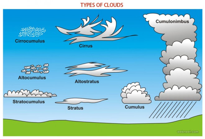
 Describe the following types of cloud and include a description of likely icing, turbulence and precipitation: 
a)  cirrostratus; 
b)  cirrocumulus; 
c)  cirrus; 
d)  altostratus; 
e)  altocumulus; 
f)  stratocumulus; 
g)  stratus; 
h)  cumulus; 
i)  cumulonimbus/towering cumulus; 
j)  nimbostratus. 

g) Stratus

  • Grey blue appearance 

Low level cloud

Grey / blue low level cloud with a fairly level base
Vertically it is no higher than 1-2000 ft

h) Cumulus

  • Formed from orographic lifting 
  • Low – Mid troposphere 
  • Unstable air 

Low cloud level
This is a detached cloud usually found in low or middle troposphere layers.
This is bright white when viewed from the sunny side but dark and menacing viewed from the base or from the shadow side

– fair weather cumulus appears mid morning on sunny days and reaches peak development mid afternoon.
Precipitation is not common in mid -latitudes but can cause brief heavy showers in the tropics
– cumulus formation from orographic lifting common in NZ
Formed when unstable air is blown over hills and mountains and when the cloud development is not associated with frontal activity or a depression 
Has a level base slightly above mountain ridge height – seen in mountains on fine days.
Depending on the degree of instability cloud tops can be a few thousand feet above the mountains or much higher – precipitation occurs when cumulus is well developed – the valleys often remain dry

a) Cirrostratus: 

  • Covers large segment of the sky
  • Thinly concentrated ice crystals 
  • No precipitation

High level cloud

This has a smooth and fibrous appearance often covering large segments of the sky
When sun or moon have a halo around them it often indicates approaching bad weather
At these heights the temperatures are often so cold that clouds consist of ice crystals and are thinly concentrated
There is no precipitation from these clouds

b)  Cirrocumulus: 

  • Thinly concentrated ice crystals 
  • Wool like appearance 
  • No precipitation 

High level cloud

Looks like a sheep’s wool appearance with small ripples arranged in a regular fashion
It can cover small or large parts of the sky.
Temps are so low that the cloud consists of ice crystals thinly concentrated and therefore no precipitation

c) Cirrus

  • Formed from ice crystals 
  • No precipitation 
  • White feather like appearance 

High level cloud

This has a pure white feather type of appearance sometimes with streaky outlines indicative of high altitude winds
The temperatures are so low due to the high altitude – cloud is formed from ice crystals and hence no precipitation

d) Altostratus

  • Thick and high water content 
  • Smooth blue grey fibrous appearance
  • Ice above freezing level
  • Varying levels of precipitation 

This is medium level cloud
Has a blue / grey smooth and fibrous appearance which often heralds approaching bad weather.
It can be substantially thick and thus have a high water content – sun or moon not visible through it.
Ice will be encountered above the freezing level
Precipitation varies at sea level – from nothing when the cloud base is high to light when the base is lower.
In mountainous terrain though precipitation occurs near the tops of hills and can be moderate to heavy or snow or sleet depending on the freezing level

e) Altocumulus

  • Grey white appearance 
  • Covers large parts of the sky 
  • Rarely precipitation 

Middle level cloud
This is a grey / white cloud which looks like Cirrocumulus but with larger ripples or rolls arranged in regular patterns.
This often covers large segments of sky often with broken patches through
Not usual for any sort of precipitation

f) Stratocumulus

  • Grey white patches appearance with dark parts 
  • Can cover entire sky 
  • Some light turbulence 
  • Light precipitation can occur 

Low level cloud
Appears as grey or white patches, sheets or layers almost always with dark parts composed of rounded masses or rolls
When “capped” by an inversion the tops are flat
Often the result of early morning mixing within the friction layer – so when formed can cover the entire sky
Some light turbulence happens in the cloud base
Precipitation of light showers or drizzle patches can occur

i) Cumulonimbus/Towering cumulus; 

  • Unstable 
  • Can reach vast heights 
  • Thunderstorms
  • Heavy precipitation 
  • Turbulence

Low – High level cloud

Associated with unstable air
Can start at low levels and reach into the middle of higher layers
Heavy, dense and accompanied by thunderstorms
Bright white when viewed from the sunny side but at the base looks dark and menacing
Precipitation in the form of rain or hail showers is common
Turbulence as well as strong up and down draughts are serious potential problems

 j) Nimbostratus

  • Stable air
  • Dark and heavy
  • Heavy precipitation 
  • Poor visibility
  • Large amounts of water

Low – High level cloud

This starts at low levels and can extend many thousands of feet upwards.
Associated with stable air
Nimbostratus is very extensive and not well defined at the edges
Looks dark and heavy
Accompanied by heavy and persistent rain (snow in colder climates)
Visibility is poor beneath the base – not suitable for VFR flying
Contains a large amount of water

8.18.8 Differentiate between cloud droplets and rain/shower drops.

Differentiate between cloud droplets and rain/shower drops.

Cloud drops are very small compared to rain drops; ie thousands of times smaller.

When cloud drops fall from clouds, their small size facilitates evaporation and remains invisible to the naked eye.

8.18.4 Explain the most common method through which cloud is formed and how air is cooled to produce cloud.

Explain the most common method through which cloud is formed and how air is cooled to produce cloud. 

The amount of water vapour in the air depends on temperature – cold air cannot hold water vapour as well as warm air. Therefore after condensation in cold air there is relatively little water within the cloud. On the other hand warm air can hold much more water vapour and for that reason clouds forming in warm air carry a great deal more water content.

Air is cooled as it rises in the atmosphere

8.18.6 Explain what is meant by “buoyancy” of air.

Explain what is meant by "buoyancy" of air.

For cloud droplets to remain suspended there must be a force which opposes the force of gravity acting on each droplet.
This force is the buoyancy of air resulting from upward vertical motion.

When this force is inadequate, droplets will fall but as they enter more dense air lower down they warm adiabatically and often evaporate before reaching the ground.

8.22.20 Explain the processes that contribute to cloud dispersal.

Explain the processes that contribute to cloud dispersal.

If the formation of cloud is caused by cooling of air through a rising process, then the principal factor in dispersal of cloud is through the warming of air through subsidence

The 3 methods by  which clouds dissipate. They are:

Sinking of air
In regions where air is subsiding, the temperature is increasing because the pressure is also increasing. Subsidence is found in anticyclones and in small areas adjacent to cumuliform clouds. Descending air is also found on the downwind side of wave crests.

Mixing with clear air
The mixing of saturated air with drier air near cumulus tops leads to evaporation of the cloud droplets. Evaporation cools the air and therefore it begins to sink. Sinking warms the air, and so further evaporation takes place.

Direct warming

Often during the afternoon, the temperature at ground level increases, but the dew point remains the same. As the temperature and dew point separate, the cloud base rises and eventually the bases may reach the level of the cloud tops causing the cloud to dissipate completely from the bottom up. 

8.22.18 Explain how, in well mixed conditions, changes in surface temperature and / or dew point relate to the cloud base

8.22.18  Explain how, in well mixed conditions, changes in surface temperature and / or dew point relate to the cloud base

The diference between the surface temperature and dew point can be a useful tool in calculating the likely cloud
base. The closer the surface temperature and dew point are, the lower the cloud base will be. 

Frequently, we awake to
a reasonably low cloud base, but during the day, the base rises as the temperature climbs, whilst the dew point
remains reasonably constant.

There are two useful rules of thumb which can be used to calculate an approximate cloud base, but they only
work on the assumption that air between the ground and cloud base is well-mixed.

The rules of thumb are: 

For convective clouds (TCu and Cb)

Cloud Base @400 x T – Td)

For all other cloud types formed by forced lifting 

Cloud Base @250 x(T-Td)

Key – T – surface temperature Td = surface dew point


8.22.16 Visually identify the following cloud types

8.22.16  Visually identify the following cloud types;

Towering cumulus

Cumulonimbus / Thunderstorm cloud

Dissipating cumulonimbus

8.22.14 Describe the following cloud types including a description of likely turbulence and precipitation

8.22.14  Describe the following cloud types including a description of likely turbulence and precipitation

This objective asks for the characteristics and associated flying conditions of the Low Cloud grouping and
lenticularis cloud 

M
I
D
D
L
E
C
L
O
U

Lenticular Ac 

– lens shaped clouds formed in
the crests of wave motions
downwind from a mountain
range. 

  • – No weather as such. 
  • – possible light to moderate ice in the updrafting portion of
    each wave. Severe ice in updrafting portion of waves where
    the airmass has originated in the subtropics. 
  • – Nil turbulence in lenticular cloud, although downdrafts may
    exceed A/C climb capabilities. 
  • Severe turbulence beneath and between wave systems,
    especially in the rotor zones. 

L O W  C L O U D

Cumulus / Towering cumulus Cb / Tcu

  •   – rainy heaped cloud with a large vertical element
  •  – upper portion usually fibrous and spread into anvil shape

In Cb’s 

  •  -showers of rian snow or hail. Possible thiunderstorms and lightning
  •  – moderate – heavy glaze ice
  •  – severe turbulence both in and below cloud 
  •  – Violent turbulence on entering / exiting cloud

In TCu

 – severe icing , moderate turbulence

Stratocumulus Sc

  •  – billowy or rolled layer of cloud
  •   – generally no precipitation but light rain / drixzzle possible – Light – moderate rime icing if freezing level is low
  •  – light turbulence especially passing through an inversion

Cumulus Cu

  •  – heap cloud developing with cauliflower tops
  •  – possible showers of rain or snow from TCu
  •  – light moderate glaze icing just above freezing level
  •  – mod – severe turbulence in and below cloud

 –

Stratus St 

  •  – layer cloud with uniform base
  •  – Drizzle with reduced visibility
  •  – usually nil icing – not cold enough
  •  – light turbulence especially passing through an inversion