6.6.2(e) Foot.
A foot is a unit of length defined as being 0.3048 m exactly.
A foot is made up of 12 inches.
It is the primary unit of indicating height in aviation.
Its symbol is ft
6.6.2(e) Foot.
A foot is a unit of length defined as being 0.3048 m exactly.
A foot is made up of 12 inches.
It is the primary unit of indicating height in aviation.
Its symbol is ft
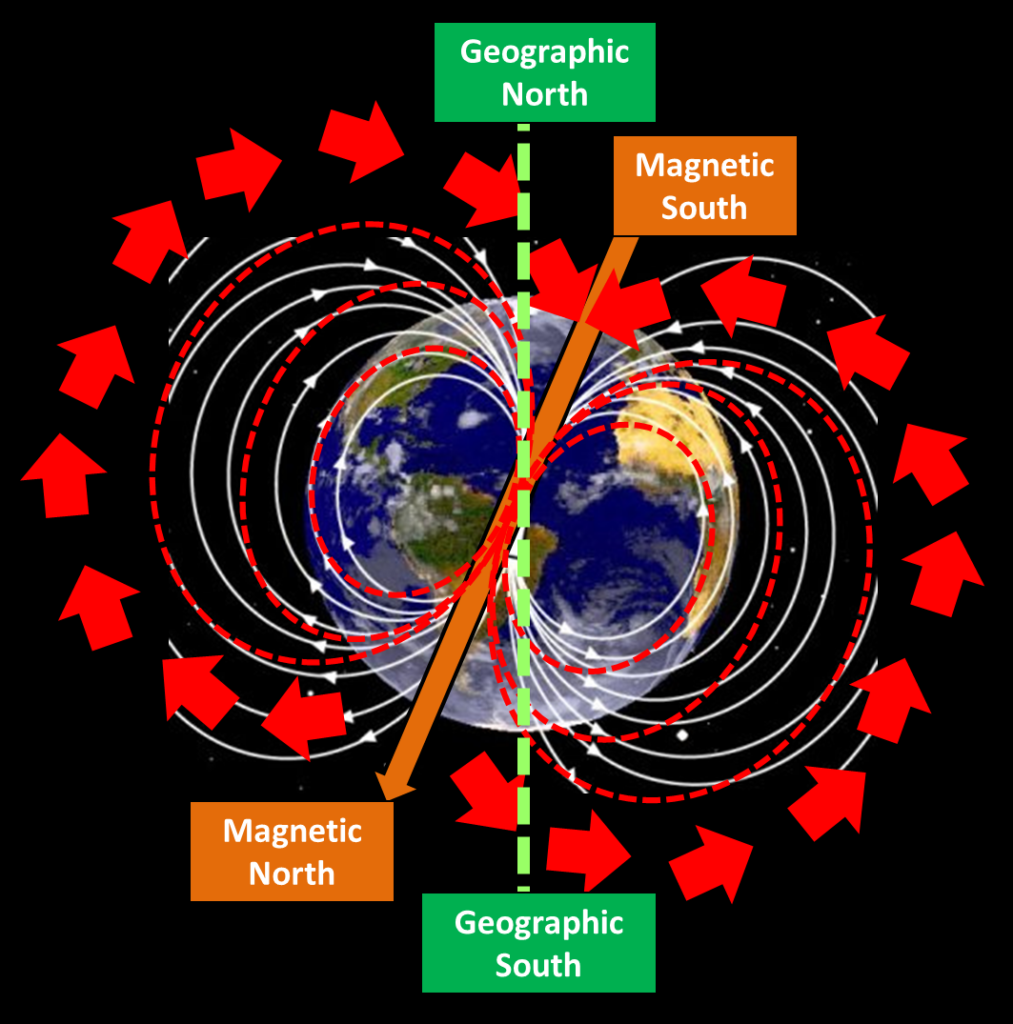
The Earth is essentially a large magnet with a field of magnetic force around it. The Earth’s magnetic poles are not situated at the same positions as the geographical poles.
The North magnetic pole is located in Hudson bay, Canada and the South magnetic pole over Antarctica.
Magnetic North Pole

Any magnet free from interference will align with the earth’s magnet fields.
Thus a free magnet, with have “Magnetic dip” and a “variation from true north”.
Magnetic dip is the angle that a magnetic needle makes with the horizontal plane at any specific location.
Magnetic dip varies at different points on the Earths surface, at the magnetic equator the dip is 0 degrees; and 90 degrees at each of the magnetic poles.
Magnetic Variation
this variation is primary due to the differing location of the geographical poles and the magnetic poles.
Isogonal lines …
on a map, these are lines connecting all points of equal magnetic Variation
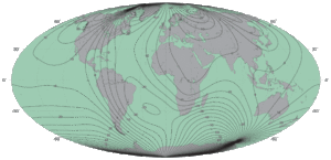
You can see from the map that the 20° east run through New Zealand.
The north-seeking end of the magnetic / aircraft compass pointe to Magnetic North.
Explain the precautions to be taken when:
a)  Inserting data with the keypad.
b)  operating/reading the unit while maintaining a proper lookout.
c)  operating/reading the unit in marginal weather conditions.
Data entry can be made worse due to the small size of some units – pressing the wrong key is not unusual, and extra care must be taken to ensure accurate information is fed into the GPS.
Rubbish in = Rubbish out
The pilot must ensure that a proper LOOKOUT is maintained at all times during the flight, and that they do not fixate on part or parts of the GPS.
With large screens displaying lots of information, it can be very easy for the pilot to become fixated on the screen with information overload.
When operating GNSS units in marginal weather conditions, the pilot must ensure they only briefly look at the screen whilst flying, and maintain a good lookout.
But above all else…
AVIATE, NAVIGATE, COMMUNICATE!
List the factors to be considered when selecting altitudes at which to fly in the cruise.
When selecting altitudes to fly in the cruise, you must take into account:
Terrain clearance (note spot highs in vicinity of your track)
Legal minimas – 500ft AGL or 1000ft ALG over built up areas
Airspace and Danger, Restricted and Military area considerations
VFR cruising levels (NOSE- North ODD +500ft, SOUTH Even + 500ft) up to 12,500ft
Weather/cloud/freezing level
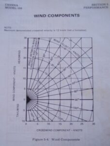
Calculate the crosswind component, given runway alignment and wind velocity.
To work out the crosswind component, we use the same graph as before.
Again we work out the difference between the wind and runway heading, and enter the information into the graph along with wind strength; which works out how much headwind or crosswind we will experience for the given runway with the given wind.
 Solve Mathematical Equations:
a)  multiplication ( 2%);
b)  division ( 2%);
c)  proportion ( 2%).
When calculating equations on your flight computer, you are allowed a 2% margin for error.
This allows for errors arising from inaccuracies in measuring distance, bearings and aligning the scales.
6.26.4. Describe the method of indicating relief on a NZ Aeronautical Chart.
Relief on an aeronautical map is shown by colour shading. Areas with low terrain are generally green, where high peaks or points can be a darker shade, possibly brown or red.
This allows the pilot to quickly distinguish the local terrain without having to read over spot heights or numbers.
