Explain the most common method through which cloud is formed and how air is cooled to produce cloud.
The amount of water vapour in the air depends on temperature – cold air cannot hold water vapour as well as warm air. Therefore after condensation in cold air there is relatively little water within the cloud. On the other hand warm air can hold much more water vapour and for that reason clouds forming in warm air carry a great deal more water content.
Air is cooled as it rises in the atmosphere
Explain what is meant by "buoyancy" of air.
For cloud droplets to remain suspended there must be a force which opposes the force of gravity acting on each droplet.
This force is the buoyancy of air resulting from upward vertical motion.
When this force is inadequate, droplets will fall but as they enter more dense air lower down they warm adiabatically and often evaporate before reaching the ground.
Explain the processes that contribute to cloud dispersal.
If the formation of cloud is caused by cooling of air through a rising process, then the principal factor in dispersal of cloud is through the warming of air through subsidence
The 3 methods by which clouds dissipate. They are:
• Sinking of air
In regions where air is subsiding, the temperature is increasing because the pressure is also increasing. Subsidence is found in anticyclones and in small areas adjacent to cumuliform clouds. Descending air is also found on the downwind side of wave crests.
• Mixing with clear air
The mixing of saturated air with drier air near cumulus tops leads to evaporation of the cloud droplets. Evaporation cools the air and therefore it begins to sink. Sinking warms the air, and so further evaporation takes place.
• Direct warming
Often during the afternoon, the temperature at ground level increases, but the dew point remains the same. As the temperature and dew point separate, the cloud base rises and eventually the bases may reach the level of the cloud tops causing the cloud to dissipate completely from the bottom up.
8.22.18 Explain how, in well mixed conditions, changes in surface temperature and / or dew point relate to the cloud base
The diference between the surface temperature and dew point can be a useful tool in calculating the likely cloud
base. The closer the surface temperature and dew point are, the lower the cloud base will be.
Frequently, we awake to
a reasonably low cloud base, but during the day, the base rises as the temperature climbs, whilst the dew point
remains reasonably constant.
There are two useful rules of thumb which can be used to calculate an approximate cloud base, but they only
work on the assumption that air between the ground and cloud base is well-mixed.
The rules of thumb are:
For convective clouds (TCu and Cb)
Cloud Base @400 x T – Td)
For all other cloud types formed by forced lifting
Cloud Base @250 x(T-Td)
Key – T – surface temperature Td = surface dew point
8.22.16 Visually identify the following cloud types;
Towering cumulus
Cumulonimbus / Thunderstorm cloud
Dissipating cumulonimbus
8.22.14 Describe the following cloud types including a description of likely turbulence and precipitation
This objective asks for the characteristics and associated flying conditions of the Low Cloud grouping and
lenticularis cloud
M
I
D
D
L
E
C
L
O
U
D
Lenticular Ac
– lens shaped clouds formed in
the crests of wave motions
downwind from a mountain
range.
- – No weather as such.
- – possible light to moderate ice in the updrafting portion of
each wave. Severe ice in updrafting portion of waves where
the airmass has originated in the subtropics.
- – Nil turbulence in lenticular cloud, although downdrafts may
exceed A/C climb capabilities.
- Severe turbulence beneath and between wave systems,
especially in the rotor zones.
L O W C L O U D
Cumulus / Towering cumulus Cb / Tcu
- – rainy heaped cloud with a large vertical element
- – upper portion usually fibrous and spread into anvil shape
In Cb’s
- -showers of rian snow or hail. Possible thiunderstorms and lightning
- – moderate – heavy glaze ice
- – severe turbulence both in and below cloud
- – Violent turbulence on entering / exiting cloud
In TCu
– severe icing , moderate turbulence
Stratocumulus Sc
- – billowy or rolled layer of cloud
- – generally no precipitation but light rain / drixzzle possible – Light – moderate rime icing if freezing level is low
- – light turbulence especially passing through an inversion
Cumulus Cu
- – heap cloud developing with cauliflower tops
- – possible showers of rain or snow from TCu
- – light moderate glaze icing just above freezing level
- – mod – severe turbulence in and below cloud
–
Stratus St
- – layer cloud with uniform base
- – Drizzle with reduced visibility
- – usually nil icing – not cold enough
- – light turbulence especially passing through an inversion
8.22.12 List the cloud types associated with each lifting mechanism
a) Orographic Lifting
To windward
all the ten basic cloud forms including Cb and thunderstorms
– Cirrus (Ci)
– Cirrocumulus (Cc)
– Cirrostratus (Cs)
– Altocumulus (Ac)
– Nimbostratus (Ns)
– Cumulonimbus (Cb)
– Towering Cumulus (TCu)
– Cumulus (Cu)
– Stratocumulus (Sc)
– Stratus (St)
To Leeward
Predominantly Ac Lenticularis and Cu/St in the form of rotor cloud
b) Convection lifting
– predominantly TCu and Cb
c) Turbulence lifting
– If stable Stratocumulus and stratus
– If unstable – fair weather Cu to full blown Cb clouds
d) Widespread ascent lifitng
Cold fronts – all types but mainly Cb
Warm fronts – mainly stratus or strato – containing clouds
Stationary and Occluded fronts – all cloud types possible – not as hazardous as cold fronts
 Describe the following methods whereby air is lifted, and include the effect of stability/instability on the type of cloud formed:
a)  orographic lifting;
b)  convective lifting;

c)  turbulence
d)  slow widespread ascent;
a) Orographic Lifting
- Air blown towards mountains and forced to ascend forming cloud
- Stable air = stratiform cloud
- Unstable air = Cumulus cloud
When air is blown towards mountains and forced to ascend it will form cloud depending on the moisture content of the air. The cloud type formed depends on the degree of stability. When the air is very moist and stable it will produce stratiform cloud form low levels and in the absence of high level moisture factors cloud tops will be found not far above mountain ridges
Unstable air with a high moisture content will produce cumulus cloud with a low base and in the absence of an inversion or a dry or stable layer aloft, cloud development may extend to great altitudes
b) Convective Lifting
- Heated surface creates convection
- Air rises with moisture content creating cumulus clouds
When the surface has heated sufficiently convection will cause air to rise and provided the moisture content of air is high enough, cumulus cloud will develop
c) Turbulence
– in this process air tumbles over obstacles like buildings, trees, hills and bluffs.
– the mechanical nature of the tumbling creates an over-turning motion with some of the air rising and thus cooling.
– if the low level atmosphere is stable for sufficient lifting and saturation of the air to occur then cloud will form
d) Slow Widespread ascent (including fronts)
- as air spirals into the centre of a low, convergence occurs at the surface, which leads to lifting over a vast area
- cloud formation surrounding a low will be due to frontal lifting , but large portions of this cloud is formed by slow widespread ascent
- Different parts of the ascent may have different stability characteristics thus any or all cloud types are likely to be found with this type of lifiting
- Caused by surface convergence in a depression
This is caused when surface convergence as experienced in a depression lifts air over a wide area
- In frontal lifting
- Cold air moves onto warm air
- Warm air forced to rise
- Creates cumulus cloud for cold fronts
- Stratiform cloud for warm front
When a cold air stream bumps into a warm one producing a cold front the warm air will be forced to rise
If a warm air stream overtakes a cold one producing a warm front the warm air will again be forced to rise because cold air is always more dense and will undercut warm air
Frontal lifting always causes warm air to rise above the cold air. Cloud is often cumuliform in cold fronts and stratiform in warm fronts
8.22.8 Describe the meaning of the following cloud terms:
Cloud Terms
| Terms |
Meanings |
| (a) CUMULUS or CUMULO (prefix) |
puffy clouds |
| (b) STRATUS or STRATO (prefix); |
layer clouds |
| (c) ALTO (prefix); |
mid-level clouds |
| (d) NIMBO (prefix) or NIMBUS (suffix); |
a dark grey cloud associated with heavy rain |
| (e) CIRRUS or CIRRO (prefix). |
high cloud |
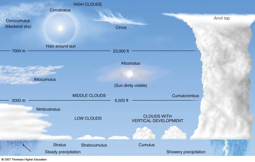
State the approximate altitude limits (in NZ latitudes) of:
a)  High cloud;
b)  Middle cloud;
c)  Low cloud.
a) High cloud – from 5 kms and higher – ( above 20,000 ft +)
b) Middle cloud – between 2-5 kms – (approx 6,500 – 20,000 ft)
c) Low cloud – below 2kms – (surface to 6,500 ft)