6.22.4(b) Describe the use of Aerodrome Chart.

6.22.4(b)  Aerodrome Chart. 

Aerodrome charts are published in the AIPNZ Volume 4 (link below)

These charts contain detailed information on many of the New Zealand aerodromes, including information such as frequencies, runway lengths, runway conditions and much more.

Link to NZ AIP

http://www.aip.net.nz/Home.aspx

Link to NZWK chart

http://www.aip.net.nz/pdf/NZWK_51.1_51.2.pdf

The Whakatane aerodrome chart is included as an example

6.16.6 Calculate ETD and ETA in UTC given planned flight time details and reference time in NZST andor NZDT.

 Calculate ETD and ETA in UTC given planned flight time details and reference time in NZST andor NZDT. 

To work out ETD, first we must convert our time of departure to UTC. Depending on the time of year, we would either subtract 12 or 13 hours (NZST / NZDT) from our time to get our ETD in UTC. 

To work out our ETA, first we must work out how long the flight will take to travel the distance with the given ground speed on the day, then add this time to our time of departure. We can then subtract the 12 or 13 hours to convert NZST or NZDT to UTC. 

6.14.2(c) Define Head/Tail Wind;

6.14.2(c)  Head/tail wind; 

A Head wind or Tail wind requires the aircraft to be flown either into the wind or away from it.

With a tail wind, we are pushed from behind, therefore flying faster over the ground.

With a head wind, with have to fly against the wind, being pushed backwards, therefore flying slower over the ground. 

winds1

6.12.2(c) Define mean sea level (MSL);

6.12.2(c)  Mean sea level (MSL); 

MSL is the sea level halfway between the mean levels of high and low tide.

6.10.2(c) Define fix;

6.10.2(c)  Fix; 

A fix is the geological position of an aircraft at a specific time determined by visual reference to ground features or reference to navigation aids. 

6.8.2(c) Define Indicated Airspeed (IAS);

6.8.2(c)  Indicated Airspeed (IAS); 

Indicated airspeed (IAS) is the airspeed read directly from the airspeed indicator in the aircraft, displayed in knots.  

It uses the difference between total pressure and static pressure, to calculate a speed through the air

6.6.2(e) Define foot.

6.6.2(e)  Foot. 

A foot is a unit of length defined as being 0.3048 m exactly.
A foot is made up of 12 inches. 

It is the primary unit of indicating height in aviation. 

Its symbol is ft


101011111212131314141515161617171818191920202121222223232424252530303535404045455050555560607070808090901 ftft arrow ft metre0.3 metremetre arrow

Earths magnetic field.

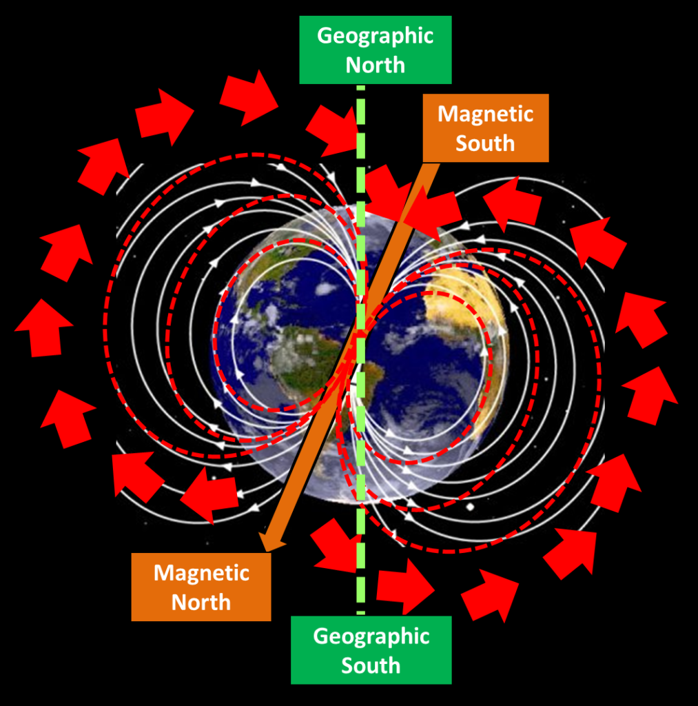
The Earth is essentially a large magnet with a field of magnetic force around it. The Earth’s magnetic poles are not situated at the same positions as the geographical poles. 

The North magnetic pole is located in Hudson bay, Canada and the South magnetic pole over Antarctica. 

Magnetic North Pole


Any magnet free from interference will align with the earth’s magnet fields. 

Thus a free magnet, with have “Magnetic dip” and a “variation from true north”.

Magnetic dip

Magnetic dip is the angle that a magnetic needle makes with the horizontal plane at any specific location. 

Magnetic dip varies at different points on the Earths surface, at the magnetic equator the dip is 0 degrees; and 90 degrees at each of the magnetic poles.
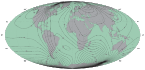
Magnetic Variation

this variation is primary due to the differing location of the geographical poles and the magnetic poles.

Isogonal lines …

on a map, these are lines connecting all points of equal magnetic Variation

You can see from the map that the 20° east run through New Zealand.

The north-seeking end of the magnetic / aircraft compass pointe to Magnetic North.


6.2.4(b) Geographic and magnetic poles;

6.2.4(b) Define and identify on a diagram of the Earth:  
Geographic and Magnetic Poles


Geographic poles are at each of the two points; the North Pole and the South Pole on the surface of a rotating planet, the line between them forms the rotational axis.


Speed & Time. Example

Example One.
You have flown a distance of 37 and in 18.5minutes.
What is you Ground Speed
The ground Speed would be 120kts 101011111212131314141515161617171818191920202121222223232424252530303535404045455050555560607070808090901. Distance of 372. Time is 18.5= Speed of 1203. One Hour(60mins)


Example Two.
You have flown a distance of 21 and in 14.8minutes.
What is you Ground Speed
The ground Speed would be 85kts 101011111212131314141515161617171818191920202121222223232424252530303535404045455050555560607070808090901. Distance of 212. Time is 14.8= Speed of 853. One Hour(60mins)


Example Three.
With a Ground speed of 95 and how far would you fly in 107.4minutes.
What will be the time to travel the distance of 170 in Minutes
With be a distance of 170nm 101011111212131314141515161617171818191920202121222223232424252530303535404045455050555560607070808090901. Speed of 952. One Hour(60mins)= Distance of 1703. Time is 107.4