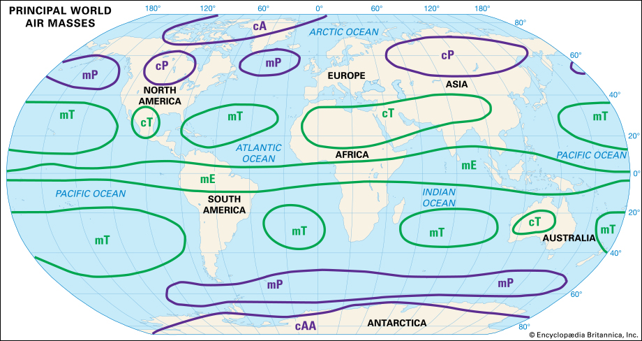
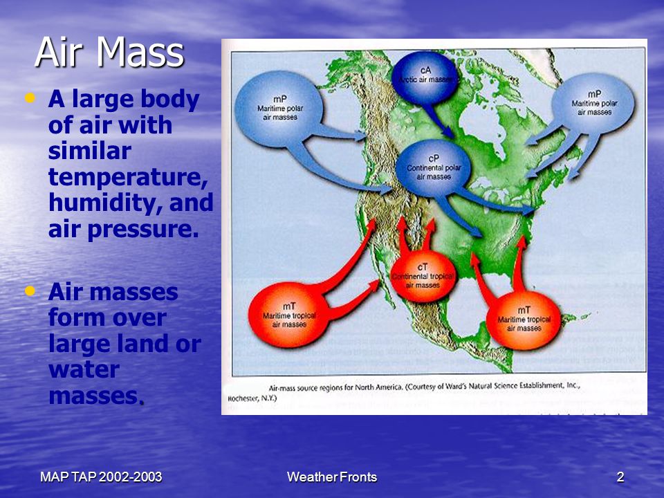
8.36.4 Different types of air masses plus 2 that routinely affect the NZ region

List the different types of air masses - plus 2 that routinely affect the NZ region

Polar Continental – cold and dry

Polar Maritime – cold and slightly moist

Tropical Continental – warm and very dry

Tropical Maritime – warm and very moist

Tropical Maritime and Polar maritime are the 2 main air masses affecting NZ

8.36.2 Air mass

Define air mass.

Air mass is a large block of air within which the temperature and moisture content have uniformity over great horizontal distances – hundreds or even thousands of kilometres
They generally form under stationary anticyclonic conditions where winds remain light for a period of at least 5 days

8.32.12 With regard to VFR flight in a light aircraft in mountainous terrain, describe the meteorological factors that should be considered during the flight planning phase and en-route

8.32.12 With regard to VFR flight in a light aircraft in mountainous terrain, describe the meteorological factors that should be considered during the flight planning phase and en-route

Every weather situation presents somewhat different conditions in mountainous terrain. On any two occasions when
the weather patterns look the same, the weather experienced along a well flown route may be surprisingly dissimilar.
For this reason, it is not possible to give complete instruction on this objective. There are, however, some points in
relation to each of these elements that may prove useful.
The following points are made on the assumption that conditions are flyable in and around the Southern Alps.
Note: When flying in the mountains it is essential that you prepare well. This includes:

  •  – Knowing your own limitations and sticking to them
  •  – Knowing the limitations of the aircraft
  •  – Being fully prepared for the flight – including;
  •  – Having the latest up to date weather forecast
  •  – Studying the route thoroughly, including spot heights for saddles etc
  •  – Considering weather a valley is wide enough to make a safe U-turn in
  •  – Knowing the position of wires, and clearly marking them on the map
  •  – Planning and conducting a passenger brief
  •  – Ensuring everyone on boards is wearing suitable clothing and footwear
  •  – Thoroughly pre-flighting the aircraft – make sure navigation lights are working
  •  – Make sure everything is secured
  •  – Planning and allowing for escape routes
  •  – Having an adequate flight following and alerting service in place

So, this objective asks you to consider six specific points in relation to the meteorological factors and track selection
when flying in the mountains. They are:

(a) Cloud base;
As a rule, the cloud base will be much lower on the windward side of the ranges – often unflyable. On the lee side of
the divide, cloud bases will be high – often well above the highest ridges. Some lower level cloud may exist in the
form of rotor clouds. These should be avoided at all costs.
Cloudscapes in mountainous terrain can change very rapidly. A slight increase in moisture advected into an area of
rising air can result in the sudden formation of cloud where none existed previously. For this reason, always keep
checking behind you to ensure your escape route remains open. 

Cloud that is forming rapidly above or about far of ridges is a good indication that dew point temperatures are rising.
Rising dew points generally mean more cloud development and lowering bases, and such cloud development can
occur rapidly in mountainous terrain. 

(b) Turbulence;
To windward, light to moderate turbulence is common. Severe turbulence, though possible, is rare except in
thunderstorms.
In the lee of the ranges, severe turbulence is relatively common, especially in rotor zones, but it’s also possible
anywhere within the friction layer. In addition, hydraulic jumps as described in 8.32.6 above can create downdrafts
that may force a light aircraft into the ground. 


(c) Adverse and favourable winds; 

The path that the wind takes when flowing around and over mountain ranges is incredibly complex and is influenced by many factors. They include:

  • – Wind strength
  • – Angle of the flow near the ranges
  • – Shape of the mountain ranges
  • – Stability of the air
  • – Vertical profile of wind speed and direction
  • – Orientation of the valley systems
  • – Location of passes and higher peaks – Effects of multiple ranges

 In some valleys, the flow will align itself with the valley – either up it or down it. Flying in these valleys is generally not
a problem. In others, however, the wind may be across the valley, and this frequently sets up a rotation in the vertical
which could be clockwise or counter-clockwise depending on wind and terrain considerations (see Figure 78 below).
In this case, it would be advisable to establish which side of the valley is updrafting, and which side is down-drafting.
Avoid the down-drafting side if possible – the combination of rising ground and descending air can be disastrous.
Flying on the updrafting side, however, will help you stay clear of terrain.

d) Visibility; 

Generally, visibility will be poor on the windward side of the range in rain, drizzle or snow. On the lee side visibility is
usually very good; however, curtains of rain or virga may exist some distance downstream from the main divide.
There are, of course, exceptions when pockets of poor visibility may still exist on the lee side, particularly if a front is
passing overhead.

In very strong winds, visibility at low-levels in east coast valleys may be reduced due to blowing dust and sand,
especially after extended dry spells in the braided river systems.
Another problem associated with visibility is one related to visual illusions and loss of horizons. Learn to visualise
where the horizon is and superimpose this line on the mountains in front of you. This will help you maintain both
attitude and altitude. 

(e) Track selection; 

Obviously, selecting a route or track to get from A to B depends on the weather on the day.
If you are lucky and the weather is fine, you can save time by flying high and in a straight line from departure to
destination, or you might use the good flying conditions to get down into the valleys and enjoy the scenery. 

If the weather is a little dodgy, however, often taking the long way around is the best option. For example, if you want
to get from Christchurch to Queenstown, the best option may be to fly down the coast to Invercargill, then fly north
via Lumsden and the valley following SH6 to Queenstown. It all depends on the weather on the day. 

Plan a route through the passes etc to your destination, but always be prepared to change your plans if the passes
are closed due weather. And of course, be wary of a pass closing behind you. 

Regardless of the track chosen, there are some useful tips to flying in the mountains. 

With little or no indication as to which way the wind is rotating in some valleys, choosing the correct side of the valley
to fly in may be problematical. The CAA GAP publication on Mountain Flying recommends that when flying up or
down a valley with a high trafic density (around Mt Cook for example), you should always fly on the right-hand side
so that opposing traffic will always be on the opposite side of the valley. This is certainly worthwhile in the major
valley systems where there are sometimes many aircraft flying. However, in lesser valleys, flying on the RHS may put
you in the down-drafting air – not a good idea when close to rising ground. Better to fly on the up-drafting side of the
valley and to always allow enough room to do a 180 degree turn. 

NEVER enter a valley which is too narrow to do a 180º turn in. 

When crossing a ridge, do so at a 45 deg angle. Thus, if sink is encountered, the turn back towards safety will be at
a shallower angle of bank with less wing loading and less distance to cover. Always be wary of sink approaching
the ridge-line, or during any turn-back.
In stronger winds, expect stronger sink, so approach ridge-lines at a greater height. And remember, the wind blowing
through passes or saddles is often stronger than the wind blowing over the higher ridge-lines. If you get lost flying
in the ranges, follow the biggest valley you can find downstream. Not only will the valley tend to broaden
downstream, but it will eventually lead to bigger rivers, roads, and towns where you can re-orientate yourself.

 (f) The anticipated timing of any expected weather change;
Thorough pre-flight planning, including asking yourself “what if?” will help you to be ready for in-flight conditions
that you were not anticipating. Weather in the mountains can and frequently does change very quickly. Set your
personal minima and stick to them. If conditions are deteriorating and are getting close to your personal pre-set
minima, play your Joker card and turn back immediately. 

Note any scraps of cloud developing where none previously existed. They may indicate that higher moisture content
air is being advected into the area.
During the hours prior to the planned flight, keep an eye on the sky. If upper level lenticular waves are slowly moving
away from the generating range, the upper level winds are increasing, even though the surface winds may not be.


Another rule of thumb:

If the mountain airfield TAFs have three or more QNH forecast lines indicating RAPIDLY falling pressure, consider cancelling your proposed flight. The weather WIILL deteriorate over the next 5-10 hours and once the deterioration starts it will be rapid

8.32.10 Explain the associated dangers of rotor zones to aircraft operations

8.32.10 Explain the associated dangers of rotor zones to aircraft operations

The image above was taken in Patagonia, Argentina Similar
cloud-scapes are often observed about and east of the ranges in the South Island, and occasionally east of the North
Island ranges in very strong west-northwest flows. 

The roughened, almost black rotor cloud in the foreground toward the top right of the image is the only indicator as
to the presence of rotor zones.  It should be noted, however, that this will not be the only rotor zone within the area encompassed by this image.
Underneath the crests of any lenticular clouds, there is the potential for rotor zones to exist, and often, between
wave systems at higher-levels, counter-rotating rotors may also exist. 

If you imagine drawing a line diagonally across this image from the top le` to the X in the lower right-hand
corner, you will almost certainly be drawing a line through the centre of further rotor zones. These zones are
not indicated by clouds, however, because most of the lower-level moisture has been removed by rain on the
western side of the ranges.

 The chaotic nature of rotor zones, and thus the likely severe turbulence, is indicated by the ragged appearance of
any rotor cloud that does form. Rotors tumble rapidly, and the cloud associated with them (where it exists) is
constantly and rapidly changing shape.

A cursory glance at rotor cloud will reveal perhaps nothing more than a scrap of ragged, thin looking cloud which you
may feel you could fly through in a few seconds. However, if you take the time to watch the cloud for a minute or two,
you will observe its truly violent nature. 

The wind-shears associated with rotor zones have been known to destroy aircraft` in flight. In 1995, at the
World Gliding Championships held out of Omarama in the South Island, a brand-new Nimbus 4 glider broke up
in flight when the aircraft flew into a rotor zone between wave systems at 8000` just north of Lindis Pass.
Gliders are built to fly in potentially very rough conditions, however this one, having never been stressed in
flight before, was unable to withstand the strains encountered in the aggressively revolving rotor. Other
anecdotal stories exist of aircraft` entering a rotor zone, and the pilot suddenly finding themselves upside down
and completely out of control.

8.32.8 Describe the formation of rotor

8.32.8 Describe the formation of rotor

Rotor Zones form when the flow through the ridge or trough of a wave system is so fast that it sets up a rotation in
the horizontal about the centre of rotation in the ridge or trough curvature. 

Alternatively, if the pressure difference between the windward and leeward side of the ranges is sufficient to force
the strong winds all the way to ground level on the lee side, the low-level wind is retarded by friction with the
underlying earth creating a rotation at low levels which develops into a low-level rotor zone. The low-level wind is
effectively caught in the undertow of the land. 

Rotors are extremely turbulent and have destroyed aircraft in flight in New Zealand. Often the rotor zone will form in
a reduced moisture environment. When this happens, the rotor still exists, but there will be no cloud to signal its
existence. For this reason, flight in the zones where rotors are likely to exist should be avoided at all cost. 

The
favoured areas for rotors to form are: 

  • ➡ Under the crests of each wave system (indicated by the presence of high level lenticular cloud. 
  • ➡ Immediately in the lee of the ridge-line at about ridge-top height. 
  • ➡ At higher levels, in the troughs of the wave system between lenticular cloud lines. 
  • ➡ At very low-levels when the northwest wind is touching down at the surface.

8.32.6 Describe the mountain lee wave (standing wave) development process

8.32.6 Describe the mountain lee wave (standing wave) development process

Under suitable conditions, air which has been forced to rise over a mountain range will form a series of lee waves,
often spreading hundreds of kilometres downwind from the generating range. 

This happens when the air that has been displaced upward on the windward side of the mountain barrier encounters
a stable layer at about ridge-top level which provides the restoring force for descent on the lee-ward side. Like a
pendulum, the equilibrium point is over-shot and a downstream series of vertical oscillations is formed. 

Lee waves are frequent and often well developed over New Zealand in northwest flows. They can extend downstream
of mountain ranges for several hundred kilometres before they eventually dampen out over the ocean. 

Vertical speeds of several thousands of feet per minute can occur. The wave system can extend to 80,000 ft over the
Southern Alps while gliders have soared to 36,000 ft in the Wairarapa of hills about 5000 ft high. The wavelength
depends on the speed of the wind and the stability of the air. Wavelengths are typically 10-40 km. The amplitude of
waves is determined by the shape of the mountain range (see figure 76). 

Multiple ranges can have the effect of cancelling out the wave, or, on rare occasions, of doubling the amplitude and
halving the wave length. This can result in a phenomenon known as an ‘Hydraulic Jump’. Hydraulic jumps can create
extremely strong down-drafting air which has sufficient force to flatten large expanses of forest. A light aircraft
attempting to fly through a hydraulic jump is almost certainly courting disaster. 

Encountering a down-drafting portion of the wave near ground-level, or immediately upwind from rising ground can
also be fraught with danger.

8.32.4 In Fohn wind conditions describe the typical weather for the following

8.32.4 In Fohn wind conditions describe the typical weather for the following;

a) To windward side of the mountain range

b) Above the mountain range

c) On the lee side of the mountain range

(a) To windward of the mountain range; 

When Föhn conditions exist in the east of the country, the weather to windward of the mountain range will almost
certainly be unflyable by most pilots. Cloud bases will be extremely low (perhaps 100 to 500ft AMSL), often with
heavy precipitation and very poor visibility. Frequent embedded thunderstorms are also a distinct possibility.
Definitely NOT VFR flight conditions. 

(b) Above the mountain range;

About and immediately to the west of the ridge line, conditions will be like those explained in (a) above,
with the addition of extremely strong winds, especially through the passes and valleys leading up to them. 


(c) On the lee side of the mountain range. 

Immediately to the east of the ridge line, there will be a rapid clearance of most of the cloud below the mountain tops.
This is because the air immediately in the lee of the mountain range is ‘dumping’ and therefore warming up causing
the cloud to evaporate. Often, a layer of higher cloud with bases around 15 – 20,000 ft will exist.
Often the precipitation doesn’t stop, as large rain droplets can be blown well downstream and appear to fall from
relatively clear skies. Visibility in this rain is usually not bad, however, as the droplets are widely spaced.
So, weather wise, flight conditions in the east could best be described as OK for VFR flight. However, the big problem
will be the large areas of moderate to severe turbulence at heights between ground level and about 1.5 times the
115
Meteorology for PPL Pilots (Ed 2) © Meteorological Service of New Zealand Ltd
height of the range. At times, in strong flows, this turbulence may border on extreme, especially in rotor zones (see
figure 59).

8.32.2 Define Fohn Wind

8.32.2 Define Fohn Wind

The Föhn wind is a warm, dry and very gusty wind blowing down the lee side of a major mountain range. ‘Föhn’ is
the name of the strong southerly wind which blows over the Alps in Europe, and the name has been adopted here in
New Zealand to describe the strong Nor-wester which frequently blows from the Hawkes Bay to south Otago.

8.30.10 Explain the origin and development of tornadoes and state the main hazards.

Explain the origin and development of tornadoes and state the main hazards.

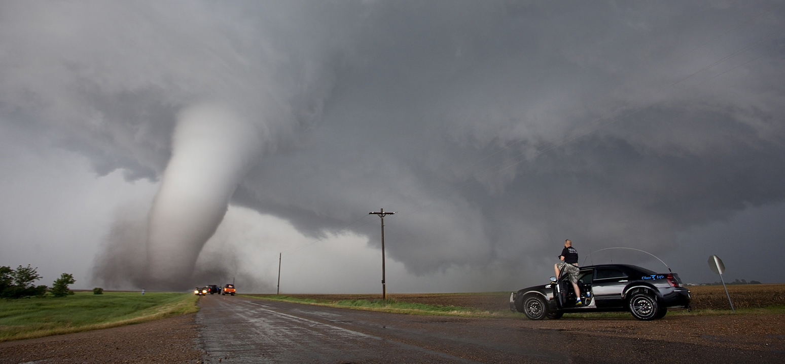
Tornadoes are rotating funnels or air sucked up from below the base of Cumulonimbus cloud
They are caused by extremely strong upward motion

The high rotational velocity of a tornado is produced when there is an existing rotation of air beneath the Cb and this air is drawn into the base of the cloud through convergence

Hazards:
Windshear at low altitudes – at particular risk on take off or approach

8.30.8 Explain why light aircraft should always avoid flight in the vicinity of thunderstorms

8.30.8 Explain why light aircraft should always avoid flight in the vicinity of thunderstorms

  • While many aircraft have successfully flown through thunderstorms in New Zealand and overseas, there is a very
    large number of aircraft that have crashed during the attempt. 
  • The dangers are simply not worth the risk. 
  • In terms of
    VFR flight anywhere near Cb clouds by inexperienced PPL pilots, the best advice is simple:
    AVOID AVOID AVOID