Describe weather conditions and degrees of visibility in:
a)  stable air;
b)  unstable air.
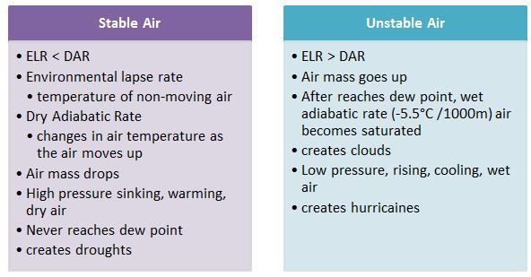
a) Stable conditions associated with poor visibility due to fog and stratiform cloud
b) Unstable conditions are normally associated with cumulus cloud, which can reduce visibility
Describe the types of cloud that could be expected in:
a)  stable saturated air;
b)  unstable saturated air.
a) When air is stable and water content is high, when a rising mechanism is present low level Stratiform cloud or fog may form.
If stable air is less moist the cloud base will be higher
b) When air is unstable and moisture content is high, low level cumuliform cloud will form.
When air is less moist cloud bases will be higher and cumulus clouds are often wider apart
Explain the effect of increasing surface temperature on the base of convective cloud, given a constant moisture content.
________________________________________
Discussion
Explain how different Dew Point values determine the cloud base.
If the air has a very low Dew Point, ie it is very dry even though the rising parcels cool at the DALR of 3 degrees / 1000ft they will not cool to below the dew point and therefore condensation will not take place.
If the air’s Dew Point is higher ie air is moist the rising dry air will cool adiabatically to below Dew Point and condensation occurs. Cloud will form and since the air is unstable this will be cumuliform cloud.
Explain the factors involved in thermal rising of air.
Thermal rising takes place when the surface becomes hot and very dry air rises due to instability.
If the air is less dry, cumulus cloud will form at some height and this will be lower if the water content of the unstable air is greater.
The hotter the surface and the drier the air the higher the cumulus cloud base
Explain how the relationship between the ELR and SALR can be used to determine the stability or instability of saturated air.
Stable saturated air – SALR lies below ELR
Unstable saturated air – SALR lies above ELR
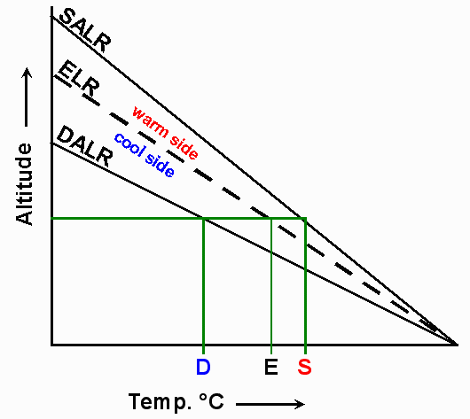
Explain why inversions and isothermal layers are atmospherically very stable;
A parcel of air lifted through the atmosphere must cool at either the DALR ot the SALR
When this parcel passes through an inversion its internal temperature will be cooling while the surrounding environment is warming up
If the lifting force were to cease its internal temperature will certainly be lower than the environment surrounding it – parcel will want to sink back into its starting position = stability
If a lifted parcel is passing through an isothermal layer the same process occurs except the temperature differences will not be as marked
Define the following…
‘
a) Inversion
The usual environmental lapse rate is such that temperature decreases with increasing height through the troposphere.
An inversion is a shallow layer where the opposite of this occurs – temperature increases with increasing height
b) Isothermal Layer
An isothermal layer is one through which temperature remains constant with increasing height
State the conditions needed for the conditionally unstable air to be forced to become unstable;
When forced to rise, conditionally unstable air may become unstable if certain conditions are met
To become unstable a sufficient depth of cloud must form – which results in the release of latent heat which will slowly destabilise the rising parcel of air
Air forced to rise -> subject to less Pressure -> Expands -> Cools
Continued cooling -> Condensation -> Cloud formation – Release of latent heat -> Destabilisation occurs
State the saturated adiabatic lapse rate (SALR).
SALR = 1.5 deg Celsius per 1000 ft
When air cools, its relative humidity increases and condensation will occur if cooling continues after the dew point temperature has been reached.
The condensation process releases Latent Heat
The Saturated Adiabatic Lapse Rate is the consequence of this heat being released; reducing the Adiabatic rate at which air cools