8.4.6 Define pressure gradient.

8.4.6 Define pressure gradient.


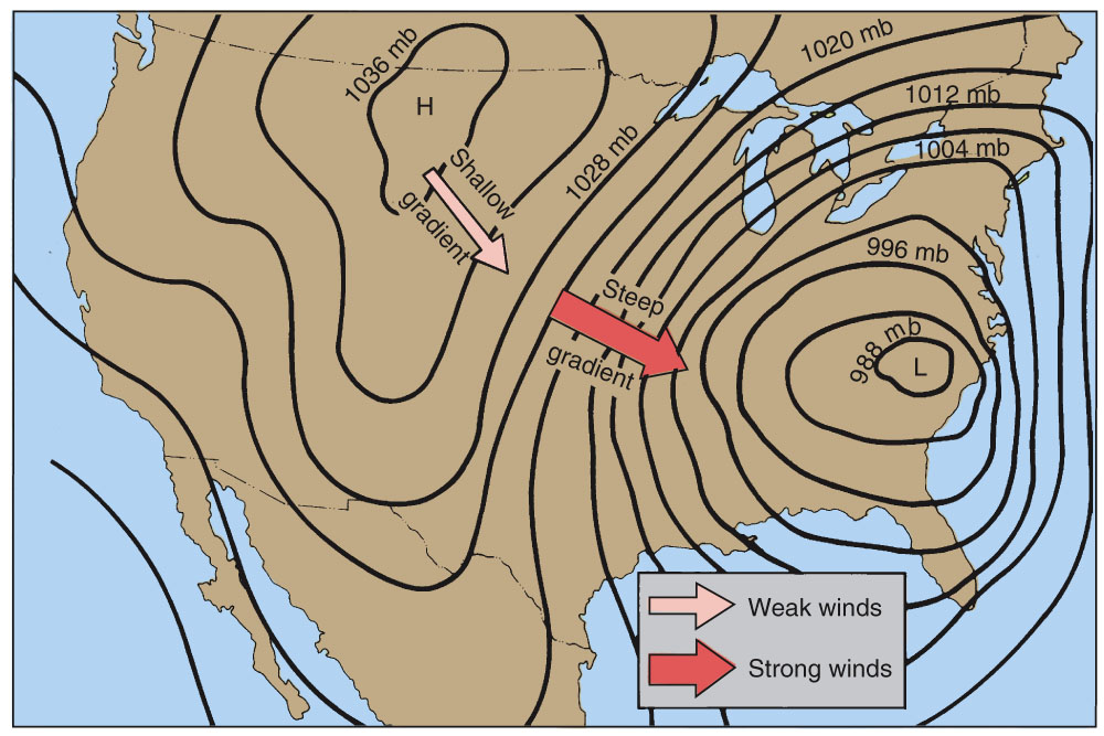
h) Pressure gradient is the atmospheric pressure change per horizontal distance.

Higher – Stronger Wind
Lower – Winds light

The Pressure Gradient is the difference in pressure per horizontal distance – it is a force – always acting at right angles to the isobars and always from High to Low

8.4.4 Explain the most common weather characteristics of each feature.

8.4.4 Explain the most common weather characteristics of each feature.

8.4.2-4 Identify the following features found on surface weather maps:

8.4.2 Identify the following features found on surface weather maps:
(a) isobars;
(b) anticyclone (“high”);
(c) depression (“low” or “cyclone”);
(d) ridge of high pressure;
(e) trough of low pressure;
(f) col;
(g) fronts (cold, warm (warm sectors), occluded and stationary);
(h) tropical cyclones.
8.4.4 Explain the most common weather characteristics of each feature.


Weather Map Features
Features Identify / Characteristics
(a) isobars;
(b) anticyclone (“high”);
(c) depression (“low” or “cyclone”);
(d) ridge of high pressure;
(e) trough of low pressure;
(f) col;
(g) fronts (cold, warm (warm sectors), occluded and stationary);

(h) tropical cyclones.
Define and describe:
a)  isobar; 
b)  wind velocity; 
c)  anticyclone (high); 
d)  depression (low); 
e)  ridge of high pressure; 
f)  trough of low pressure; 
g)  col; 
h)  pressure gradient. 

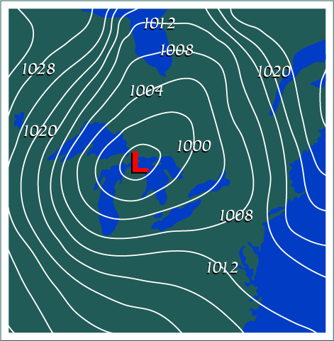
a) An isobar is a line of equal pressure; as displayed below

  
lll

b) Wind velocity is strength and direction of the wind for a given height or area. 

Such as 270/15 this means the wind is coming from 270 degrees, at 15 knots 


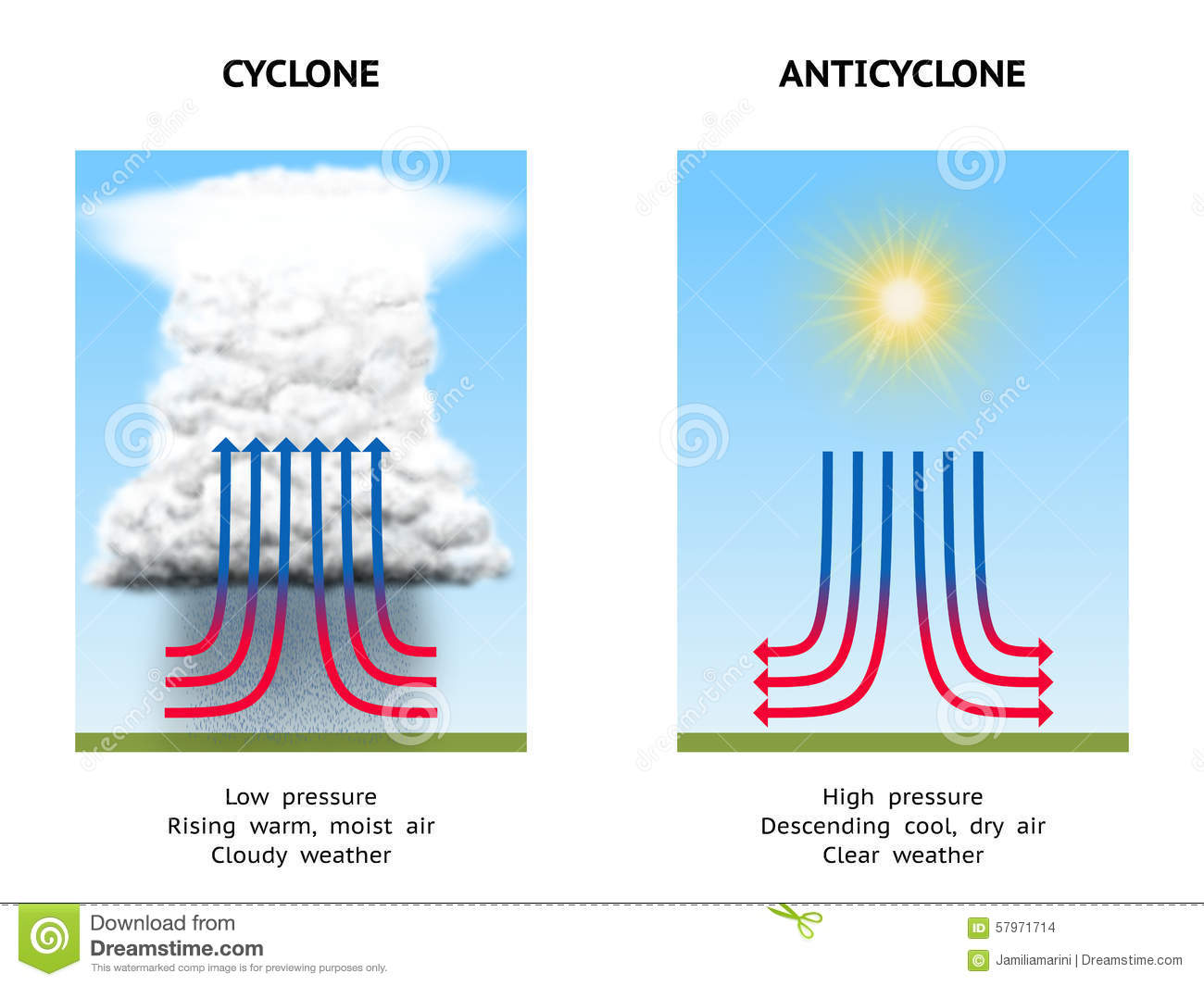
c) Anticyclone (high)
System with greatest pressure in the the centre.
Wind rotates Anticlockwise (Southern Hemisphere).
Air subsides(goes down) compresses and warms.

d) Depression (low)

System with lowest pressure in the the centre.
Wind rotates Clockwise (Southern Hemisphere).
Air rises causing expansion and cooling thus invisible water vapour may condense into visible water, clouds.

huhhu

e) A ridge is an extension off a High and has the same characteristics as the High

f) A trough is an extension off a Low and has the same characteristics as a Low

g) A col is an area between 2 highs and 2 Lows.
Wind is very light or calm.

uhuh

h) Pressure gradient is the atmospheric pressure change per horizontal distance.

Higher – Stronger Wind
Lower – Winds light

The Pressure Gradient is the difference in pressure per horizontal distance – it is a force – always acting at right angles to the isobars and always from High to Low

MetFlight Use

In order to obtain the applicable weather information for your flight, first you must log on.

Once logged in, you are shown a map of the country. You must click on the the areas of the map that are applicable with your flight (the areas that you will be flying to/in) 

Once the areas are selected, click on “get weather briefing” to be presented with the appropriate weather including; SIGMETS, ARFORS, TAF’s and METARS.

MetFlight’s other features also include things such as Webcams, Radar, cloud and rain forecasts as well as other charts and features than provide you with information on the prevailing weather conditions and forecasts. 

Have a play around with all the features so that you are familiar with MetFlight and that you can make appropriate go or no go decisions. 

MetFlight Login

To create a login:

To get access to MetFlight GA you need to enter your: Username  and  Password …

Username:

The first input field in the logon process (Username) is the pilot licence number for CAA Licensed (Part 61) pilots, or the membership or flying certificate number for those people who are a member of a Part 149 Aviation Recreation Organisation.

Note: For the Part 149 Aviation Recreation Organisation members, a prefix is needed in front of the membership number (usually the first letter(s) of the name of the organisation) to avoid confusion between membership numbers of different Part 149 organisations. No prefix is required for CAA Part 61 pilot licence numbers.

Password:

The second field in the logon process (Password) for CAA Part 61 pilots is the INITIAL GRANT DATE of their license (lower right side of license) as set out on the reverse side of the license but input in the form d/mm/yyyy – ie; with NO leading zero on the day but WITH a leading zero on the month (eg; 5/12/2003 or 21/01/1991).

Do not forget the ‘/’ in the password as shown in the previous example.

MetFlight Website

MetFlight is an online service providing VFR weather information applicable to flights under 10,000 ft within the NZZC.

The website can be found at :

www.metflight.metra.co.nz

8.44.10 Interpret and assess weather information made available by: Internet, newspapers television, and radio.

Interpret and assess weather information made available by: Internet, newspapers television, and radio. 

Do an overview first of the weather chart
Identify the main features first
eg any depression, fronts – warm front , cold front

Anticipate the timing of fronts passing through based on the movement of air mass from West to East
Look for anticyclone features to the East of the country and ridges of high pressure

Pressure Trends
Look at the isobars – they relate to QNH at various places on the chart
Note the dfferences between the isobars

Wind Velocity
The wind blows parallel to isobars – clockwise around a low and anticlockwise around a high
Wind strength is related to the spacing of the isobars
A general impression can be obtained

Weather Systems
Pay close attention to highs lows and fronts
The degree of curvature of isobars at a cold front will indicate the severity of the front
Lowering cloud base and rain are to be expected with the approach and arrival of a warm front

8.44.8 Meteorological Services

With respect to NZ FIR VFR operations, interpret, understand and assess information of all the descriptions contained in the following; 
a)  area forecast (ARFOR); 
b)  meteorological reports (METAR/SPECI/ METAR AUTO); 
c)  trend forecasts (TREND); 
d)  aerodrome forecasts (TAF); 
e)  SIGMET; Advisory Circular AC61-3 Revision 19 17 May 2013 51 CAA of NZ Sub Topic Syllabus Item 
f)  Automatic terminal information service (ATIS); 
g)  Aerodrome and weather information broadcasts (AWIB); 
h)  Basic weather reports (BWR); 
i)  Pilot reports; 
j)  Radar and Satellite imagery. 

a) ARFOR 

This is a forecast for a specified area and is intended for those planning domestic flights up to 10,000 feet
There are 17 Forecast areas in NZ
Each is identified by a name not specific to a province or to a prominent city within the area

Consists of

– Issue Time
– Maximum and Minimum QNH
– Landing Forecast

b) METAR / SPECI – for main / military airports
    METAR AUTO – all remaining airports

c) TREND

This is a Landing Forecast
Appended to a METAR or SPECI from an International airport
Also appended to the reports from military airports
The period of Landing Forecast is 2 hours
Not appended to METAR Auto reports
Recent Weather
Wind Shear

d) TAF

These are four specified periods, which are prepared and distributed in the TAF code.
A TAF covers the airspace within a radius of 8 kms from the Reference Point of the aerodrome
Issued every 6 hours starting at 0000 UTC

Should be issued at least 2 hours before their period of validity commences
During Daylight Saving the UTC issue time is put back one hour so the same local time applies throughout the year

Contains:
– Date and Time of Issue
– Date and Period of Validity
– Surface Wind
– Visibility
– Expected Weather Conditions
– Cloud Amount Height of Base
– Change Groups
– Probable Changes
– 2000ft Wind
– Missing TAF
– Maximum and Miniumum QNH
– Landing Forecast

e) SIGMET

This is issued for potentially hazardous weather conditions in the NZ domestic FIR and Auckland Oceanic FIR
Has a validity of 4 hours
In the case of volcanic ash or tropical cyclones the period is 6 hours

Reason for issue of a SIGMET
– Thunderstorms, obscured, embedded, frequent or in a squall line with or without intense hail
– Severe icing – in cloud due to freezing rain
– Tropical cyclone
– Heavy sand or dust storm
– Volcanic ash cloud

When the SIGMET is issued it is included in pre-flight information and passed to all affected aircraft
SIGMET have serial numbers and after 0000 UTC goes back to 01

f) ATIS

ATIS contains Take-off and Landing reports including the following:
– location and ATIS designator
– time of issue
– runway in use
– wind direction in degrees Magnetic and speed in knots
– visisbility reported in metres up to 4900m and kilometres from 5 kms
– low cloud in feet above aerodrome elevation
– present weather if significant
– temperature, dew point and QNH
– Other – wind shear, turbulence, type of approach etc
– reported or forecast 2000 ft wind

g) AWIB

This is an automatic broadcast of operational and weather information at unattended aerodromes.
Similar to the ATIS
The reports are prepared by local pilots or other people with meterological knowledge
The frequency for the AWIB is published on the Aerodrome chart – sometimes needs to be triggered by the aircraft radio transmitter

h) BWR

This is a verbal report on the actual weather conditions at a given place – usually a non attendance aerodrome
Personnel must be trained appropriately and have the skills to provide the report and ensure all equipment used is properly calibrated and maintained

BWR contains:
– wind direction in Magnetic degrees
– QNH
– ambient air temperature
– weather conditions and cloud cover

BWR must not take the place of a METAR or SPECI

I) Pilot Reports (PIREP)

Also called Aircraft Reports (AIREP)

Must report turbulence and icing especially if severe – report to nearest ATS

Regardless if other pilots have reported same or SIGMET already issued

Must also report :

Wind Shear – report height or height band the wind structure above and below the shear zone the magnitude of the associated temperature inversion and effect o the aircraft such as air speed change or drift changes etc

Volcanic Ash Reports

– give location of volcanic activity, air temperature, spot wind and horizontal and vertical extent of ash cloud

Severe Mountain Wave

Thunderstorms without hail

Thunderstorms with hail

Heavy dust / sandstorm

j) RADAR and Satellite Imagery

Often referred to as synoptic charts; can be drawn for various altitudes but most commonly shown as MSL (mean sea level) charts. 

Radar synoptics show an overview of weather systems, which gives you a better appreciation and understanding of what weather systems are doing, and how they may affect us as pilots. 
8.44.6 Describe the principle of operation, and operational effectiveness of the automated visibility sensor

Describe the principle of operation, and operational effectiveness of the automated visibility sensor

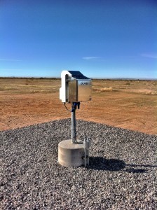
A visibility sensor measures the visibility in the immediate vicinity of the sensor probe – not the whole sky

The common sensor used is the Valsala Laser Ceilometer – installed at busy airports in NZ

Using inputs from a low powered infra-red laser beams the cloud base is continually monitored by analysing the echo reflected back from the cloud

The system can detect multiple cloud layers, rain, snowfall and fog

When visibility data from an electric sensor are received by a pilot, they should consider the fact that this is the visibility data for the immediate area and other areas around the aerodrome could be vastly different.

Always treat this data with caution

8.44.4 Describe how cloud and cloud base are reported.

Describe how cloud and cloud base are reported.

Cloud cover is reported in the Amount mode – not in the Type mode
NSC – No Signifiant Cloud
FEW – 1-2 oktas
SCT – 3-4 oktas
BKN – 5-7 oktas
OVC – 8 oktas
CAVOK – Ceiling and Visibility OK

Cloud base is reported as a 3 figure number in feet above aerodrome level

SCT016 – means 3-4 oktas of cloud with a base of 1600 ft agl (above ground level)

BKN040CB – means 5-7 oktas of cumulonimbus with a base of 4000ft agl