With reference to cloud amount, explain the meaning of:
a)  SKC;
b)  NSC;
c)  FEW;
d)  SCT;
e)  BKN;
f)  OVC;
g)  CAVOK.
a) SKC – Sky Clear
b) NSC – No Significant Cloud
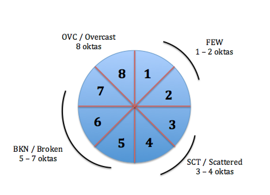
c) FEW – 1-2 oktas
d) SCT – 3-4 oktas
e) BKN – 5-7 oktas
f) OVC – 8 oktas
g) CAVOK – “Ceiling and Visibility are okay”
– This is used when the visibility is 10 km or more,
– there is no cloud below 5000ft – (or below the minimum sector altitude [ IFR] )
– no CB or TCU (cumulonimbus and towering cumulus without anvil respectively)
– no precipitation and no thunderstorms
* One okta is 1/8th of the sky covered , ie 4 oktas is about half the sky cloud covered and 8 oktas is completely overcast
Include PIREPS and AIREPS, these are an important part of the weather system
– good feedback from pilots provides better information for other pilots
– all pilot reports are passed back to Metservice and if severe weather was encountered there may be a SIGMET issued
– any information is good and able to be put to use
Basic Weather Reports
– Verbal weather reports passed to pilots from non-certified observers near an airfield or other place such as a mountain pass
– If provided through UNICOM or ATS operator the report can be relied upon as it is accurate
Aerodrome and Weather Information Services
Operated in a similar manner to ATIS – except they are non-certified and the information transmitted is recorded automatically
AWIB are advisory only – should not be relied upon as information may be coming from multiple non-certified private sources
Weather (MET) Card August 2017
|
ATIS
|
|
The ATIS is a continuous
plain language broadcast of the current conditions at an aerodrome, on a
discrete frequency.
|
|
Issue times
|
Irregularly, when
conditions change or deteriorate
|
|
Heights
|
Feet above aerodrome
level
|
|
Wind
|
Speed
|
Knots
|
|
Direction
|
Degrees magnetic
|
|
|
Visibility
|
Less than 5000 metres –
in metres, eg 3000
5000 metres or more – in
kilometres, eg 5KM
|
|
Cloud
|
Type
|
CB, TCU
|
|
Amount
|
SKC, FEW, SCT, BKN, OVC
|
|
|
Temperature/ Dew Point
|
Degrees Celsius
|
|
Pressure (QNH for ATIS only)
|
Hectopascals (hPa)
|
|
|
|
|
|
Weather (MET) Card August 2017
|
SIGMET
|
|
SIGMETs provide
information on observed or forecast hazardous weather conditions.
|
|
Issue times
|
As required
|
|
Validity
|
Four hours (six hours
for volcanic ash and tropical cyclones), reviewed after three hours or when
further information available
|
|
Heights
|
Feet above mean sea
level up to 10,000 feet, flight levels from FL 100
|
|
Area
|
New Zealand FIR (NZZC)
and Auckland Oceanic FIR (NZZO)
|
Weather (MET) Card August 2017
|
METAR, METAR AUTO and SPECI
|
|
A METAR is a routine
meteorological report, compiled manually, provided for a specific aerodrome,
and presented in code.
A METAR AUTO is a
routine meteorological report provided by an automatic weather station (AWS)
for a specific aerodrome, also presented in code.
A SPECI is a METAR
issued outside of the routine issue time of a METAR (NZWP, NZOH and NZMF
only).
|
|
Issue times
|
METARs issued hourly, on
the hour
METAR AUTOs issued every
half hour, 24 hours a day
SPECIs issued when
required and will have issue time other than on the hour SPECIs not issued at
Metar Auto aerodrome
|
|
Heights
|
Feet above aerodrome
level
|
|
Area
|
Within 8 km of the
aerodrome reference point
When the term VC is used
this applies to the area between 8 and 16 km from the aerodrome reference
point
|
|
Wind
|
Speed
|
Knots
|
|
Direction
|
Degrees true. When
direction varies by 60 degrees or more, the extreme directions are given,
separated by the letter V, e.g. 260V330
|
|
|
Visibility
|
Up to 9999 metres – in
metres, eg 7000
Above 9999 metres – in
kilometres, eg 20KM
Visibility variation
shown by adding the direction, eg 2000SW – visibility variation not reported
in METAR AUTO
CAVOK and 9999 (10 KM or
more) used at Auckland, Wellington and Christchurch only
|
|
Cloud
|
Type
|
CB, TCU
|
|
Amount
|
NSC, SKC, FEW, SCT, BKN,
OVC
|
|
|
Temperature/ Dew Point
|
Degrees Celsius
|
|
Pressure (QNH)
|
Hectopascals (hPa)
|
|
|
|
|
|
Weather (MET) Card August 2017
|
TAF and TREND
|
|
A TAF is an aerodrome
forecast provided for a specific aerodrome presented in code.
A TREND is a forecast,
valid for two hours, attached to the end of a METAR or SPECI (NZWP, NZOH
only) and METAR AUTO (NZAA, NZWN, NZCH only), stating any significant changes
from those described. While the TREND is valid it supersedes the aerodrome
TAF.
|
|
Issue times
|
NZAA, NZWN and NZCH:
2300, 0500, 1100, and 1700 UTC
All other aerodromes:
0230-0430, 0930-1015, and 1400-1445 local time
|
|
Validity
|
1921/2012 = valid from
2100 UTC on the 19th to 1200 UTC on the 20th
|
|
Heights
|
Feet above aerodrome
level
|
|
Area
|
Within 8 km of the
aerodrome reference point
|
|
Wind
|
Speed
|
Knots
|
|
Direction
|
Degrees true
|
|
|
Visibility
|
Up to 9999 metres – in
metres, eg 7000
Above 9999 metres – in
kilometres, eg 20KM
CAVOK and 9999 used at
Auckland, Wellington and Christchurch only
|
|
Cloud
|
Type
|
CB, TCU
|
|
Amount
|
NSC, SKC, FEW, SCT, BKN,
OVC
|
|
|
|
|
|
|
Weather (MET) Card August 2017
|
ARFOR
|
|
Area forecasts are
forecasts for a specific region. They are intended for domestic VFR and IFR
flights below 10,000 feet. The 17 ARFOR areas are designated by two-letter
codes.
|
|
Issue times
|
0530-0610 and 1130-1210
local time
|
|
Heights
|
Feet above mean sea
level
|
|
Area
|
Within the named area,
eg TA (Tamaki)
|
|
Wind
|
Speed
|
Knots
|
|
Direction
|
Degrees true
|
|
|
Visibility
|
Up to 9999 metres – in
metres, eg 7000
Above 9999 metres – in
kilometres, eg 20KM
|
|
Cloud
|
Type
|
AS, AC, NS, SC, ST, TCU,
CB
|
|
Amount
|
SKC, FEW, SCT, BKN, OVC
|
|
|
Temperature
|
Degrees Celsius
|
|
|
|
|
|