24.4.10
State the ISA sea level pressure and temperature conditions, and the approximate lapse rates in the lower atmosphere.
Pressure 1013.2hPa
Temperature +15° C
Density 1.225kg/m3
Temperature lapse rate 2°C/1000′
Pressure lapse rate 30’/hPa
Density lapse rate 1°C/120′
24.4.8
Describe the International Standard Atmosphere.
ISA The International Standard Atmosphere is a set of known conditions on which aircraft performance is based
Pressure 1013.2hPa
Temperature +15° C
Density 1.225kg/m3
24.4.6
Describe the normal changes in pressure, temperature and density with increased altitude.
Inc the lower part of the atmosphere, called the troposphere pressure, density and (normally) temperature decrease with altitude
Now if we put some molecules into a big tube,
you can see that the molecules at the top of the tube
will be pushing down on the molecules below them,
thus the molecules at the bottom of the tube will be pushed together the closest.
thus are more densely packed.
This is the same as our earth’s Atmosphere.
Density
Checking out the the Grey boxes,
The one that the bottom contains more molecules
thus has more Density
and then grey box at the top with less molecules
thus has less Density.
So Density Decrease (along with aircraft performance) with an increase in Altitude.
Temperature and Pressure
To easily work out what the temperature is you need to understand the effect that pressurising or creating a vacuum has on temperature
A bicycle tyre pump or a tyre compressor they all heat up hence if air in compressed(pressure Increased) the air temperature will increase.
If you create a vacuum like inside your carburettor e.g. carb icing the temperature will decrease.
So how to work out the pressure difference?
This is really simple just have a look at the distance between the molecules.
If the molecules are close together the pressure is high
if that further apart the pressure is lower.
So what you notice by studying our column of air,
is the pressure is higher thus temperature is greater at the lower levels.
At the top of the column the pressure is lower and also the temperature is the coldest.
So Pressure Decreases with an increase in Altitude
and
So dose Temperature Decrease with an increase in Altitude
|
[vfr_Pic p1=”density_column.png”] |
|
|
Describe the effect of temperature, pressure and humidity on air density. (24.4.4)
Air Density: The amount of matter/mass in a given volume.
The Effect of ...... on Density
| Effect Of .. |
Change | Mass |
Comment |
| Temperature |
Increase |
Less /m3 |
|
|
Decrease |
More /m3 |
|
| Pressure |
Increase | Less /m3 |
|
|
Decrease | More /m3 |
|
| Humidity |
Increase | Less /m3 |
|
|
Decrease | More /m3 |
|
Why do we need to have an understanding of the atmosphere:
To have an understanding of the physical properties of the
atmosphere and how this impacts to aircraft performance.
Define air density. (24.4.2)
Air Density: The amount of matter/mass in a given volume.
| Low Density |
|
High Density |
 |
|
 |
22.2.22 Interpret simple gra
Throughout our study of the Principles of Flight there are many graphs. We must be able to interpret these graph to gain the best understanding possible of the information being presented.
22.2.20 Explain the meanings of work, power and energy;
                and describe kinetic energy and potential energy.
Understanding these principles will help us understand several important points in aviation
Work = Force x Distance
Work is when a force applied to an object moves the object in the same direction as the force. If someone pushes against a wall, no work is done on the wall because it does not move.
Power = Work / Time
Power is the rate of doing work. It is the amount of energy consumed / used in time.
Power is used for ‘Thrust required, power required vs TAS’
Energy is the ability of something to do work.
Energy is measured in joules, and one joule is defined “mechanically”, as being the energy transferred to an object by the mechanical work of moving it a distance of 1 metre against a force of 1 newton.
Energy has two forms. Potential energy and Kinetic Energy. We are most interested in Kinetic energy.

Kinetic energy of an object is the energy that an object possesses due to its motion
Potential energy is energy possessed by a body by virtue of its position. I.e. it is at a height.
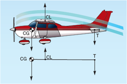
22.2.18 Explain the meaning of centre of gravity (centre of mass).
Centre of gravity is very important to us. We need to understand it as it has many applications wishing aviation
The distribution of mass is balanced around the center of mass and the average of the weighted position coordinates of the distributed mass defines its coordinates.
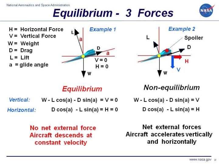
22.2.16 Describe the conditions required for translational equilibrium and for rotational equilibrium.
Equilibrium is an important concept. If we understand the principles of equilibrium we will understand the forces involved in flight a lot more easily.
An object is in translational equilibrium when the sum of all the external forces acting on the object equals zero. This also means an object is in translational equilibrium when it is experiencing zero overall acceleration. Therefore, it is either not moving, or moving at a constant velocity.
An object is in rotational equilibrium when the sum of all the external torques acting on it equals zero. In rotational equilibrium, an object either will not be moving, or moving at a constant angular velocity. This must mean the object is experiencing zero angular acceleration.
22.2.14 Describe the moment of a force, and the moment of a couple.
Having an understanding of moments and couples will help us to understand how forces are being generated in and around our aircraft.
The turning effect of a force is known as the moment. It is the product of the force multiplied by the perpendicular distance from the line of action of the force to the pivot or point where the object will turn.
A couple is two equal forces which act in opposite directions on an object but not through the same point so they produce a turning effect. The moment (or torque) of a couple is calculated by multiplying the size of one of the force (F) by the perpendicular distance between the two forces (s).
If forces are different, each side is to done done separately.

